Let’s begin by fixing our position on the surface of planet Earth. Earth’s axis of rotation defines
the locations of its North and South Poles and of its equator, halfway between. Two other
directions are also defined by Earth’s motions: east is the direction toward which Earth
rotates, and west is its opposite. At almost any point on Earth, the four directions: north,
south, east, and west are well defined, despite the fact that our planet is round rather
than flat. The only exceptions are exactly at the North and South Poles, where the
directions east and west are ambiguous (because points exactly at the poles do not turn).
We can use these ideas to define a system of coordinates attached to our planet. Such a system,
like the layout of streets and avenues in Manhattan or Salt Lake City, helps us find where we are or
want to go. Coordinates on a sphere, however, are a little more complicated than those on a flat
surface. We must define circles on the sphere that play the same role as the rectangular grid that
you see on city maps.
A great circle is any circle on the surface of a sphere whose center is at the center of the sphere.
For example, Earth’s equator is a great circle on Earth’s surface, halfway between the North and
South Poles. We can also imagine a series of great circles that pass through both the North and
South Poles. Each of the circles is called a meridian; they are each perpendicular to the equator,
crossing it at right angles.
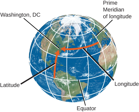
Any point on the surface of Earth will have a meridian passing through it (Figure 1). The meridian
specifies the east-west location, or longitude, of the place. By international agreement (and it took
many meetings for the world’s countries to agree), longitude is defined as the number of degrees of
arc along the equator between your meridian and the one passing through Greenwich, England,
which has been designated as the Prime Meridian. The longitude of the Prime Meridian is defined
as 0∘.
Figure 1:Latitude and Longitude of Washington, DC. We use latitude and longitude
to find cities like Washington, DC, on a globe. Latitude is the number of degrees north
or south of the equator, and longitude is the number of degrees east or west of the Prime
Meridian. Washington, DC’s coordinates are 38∘ N and 77∘ W.
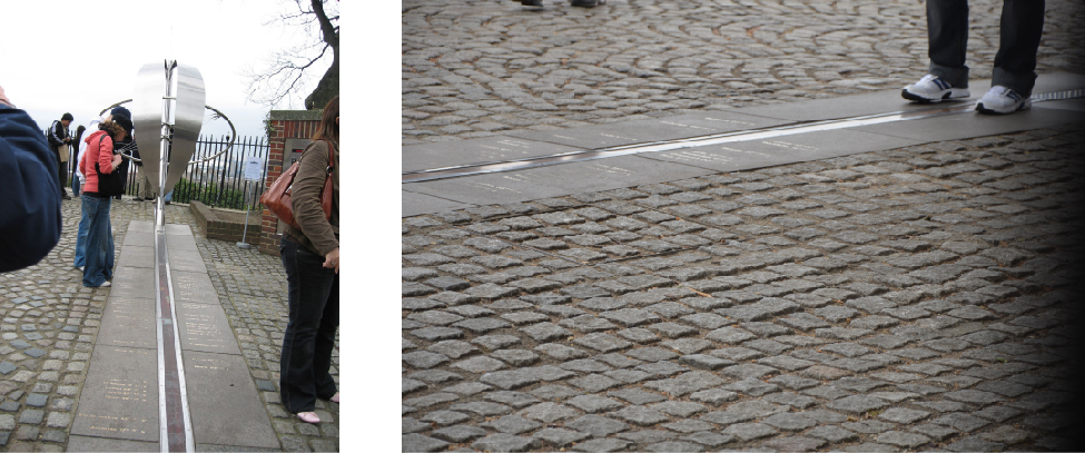
Why Greenwich, you might ask? Every country wanted 0∘ longitude to pass through its own
capital. Greenwich, the site of the old Royal Observatory (Figure 2), was selected because it was
between continental Europe and the United States, and because it was the site for much of the
development of the method to measure longitude at sea. Longitudes are measured either to the
east or to the west of the Greenwich meridian from 0∘ to 180∘. As an example, the longitude of the
clock-house benchmark of the U.S. Naval Observatory in Washington, DC, is 77.066∘
W.
Figure 2:Royal Observatory in Greenwich, England. At the internationally
agreed-upon zero point of longitude at the Royal Observatory Greenwich, tourists can stand
and straddle the exact line where longitude “begins.”(credit left: modification of work by
“pdbreen”/Flickr; credit right: modification of work by Ben Sutherland)
Your latitude (or nort-south location) is the number of degrees of arc you are away from the
equator along your meridian. Latitudes are measured either north or south of the equator from 0∘
to 90∘. (The latitude of the equator is 0∘ .) As an example, the latitude of the previously
mentioned Naval Observatory benchmark is 38.921∘ N. The latitude of the South Pole is 90∘ S, and
the latitude of the North Pole is 90∘ N.
References
This article is a derivative work of the creative commons share alike with attribution in
[1]. [1] Fraknoi, Andrew, David Morrison, and Sidney Wolff. The Sky Above. In Astronomy
2e. Houston, Texas : OpenStax, 2022. The Sky Above